
Today, I’m going to tell you about a true mountain paradise within the Julian Alps of Slovenia, and also describe one of the routes which you can use to reach it. I hope you enjoy our trip to the Seven Lakes of Triglav!
The Seven Lakes

In Slovenia they are known as both Sedmera Jezera and the Triglavska Jezera: the Seven Lakes which lie southwest of Triglav, Slovenia’s highest mountain (2,863m/9,395ft above sea level.) The lowest of the lakes is itself 1,294 m (4,245 ft) above sea level, and can only be reached by hiking, and serious hiking at that. But if you are able to make the walk, the effort is more than rewarded by the unforgettable views and the joy of a day (or two) spent in the mountains.
Here is a list of the seven main lakes of the valley (souce: Bohinj.si):
- The Lake under Vršac (also called the Lake at Podstenje; 1,993m above sea level, often frozen most of the year)
- The Pool in Laštah (under the Zasavska koča na Prehodavcih hut – often dries up during the summertime)
- The Brown Lake (150 m long, 100m wide, 10m deep)
- The Green Lake (up to 2m deep, green colour due to the algae)
- The Great Lake (also called the Ledvica (kidney) lake, due to its shape – the largest of the lakes, 1,930m above sea level, 300m long, 120m wide, up to 15m deep)
- The Double Lake (next to the Hut by the Triglav Lakes, 1,685m above sea level; when the water level is high, the two lakes turn into one)
- The Black Lake (the warmest of the Seven Lakes; 1,319m above sea level, 150m long, 80m wide, 6m deep)
Reaching the Seven Lakes and planning your trip
As I mentioned above, the Seven Lakes Valley begins at around 1,294 m (4,245 ft) above sea level, and there is no access road to the valley. The first hut in the valley, the Koča pri Triglavskih Jezerih, is reached by hiking, and there are several options. The most direct is from Ukanc at the west end of Lake Bohinj. This should take around 3 hours and 15 minutes from the valley floor, but the route is steep and I have never walked it so I can’t vouch for its difficulty. From the same starting point, you can also walk up via Komna mountain hut where you can break your journey, but this route is also demanding and takes around 5 hours. Another alternative is to drive up to the Blato Planina and set off from there (see below for a detailed description of the route.) This saves a lot of initial assent, but still takes around 4 hours one way.
Tip: Plan Ahead
Unless you are a super-fit hill-runner or alpinist, the one-way route to the valley will take at least 3 hours. So if you are planning a return trip, realistically you will need 7-9 hours, with stops. If you want to explore the valley beyond the first mountain hut, or attempt an ascent of Triglav from this base, I strongly recommend booking a night in the Koča pri Triglavskih Jezerih in advance of your visit. When we arrived, exhausted, we asked if there was space in the hut only to be told they were fully booked, so there was nothing for it but to head back down.
Even in Summer, bring waterproof clothing as the weather can change fast. As for walking with children, our 7-year-old managed the walk no problem, but we had to carry our youngest (almost 3) in a rucksack, which was no mean feat!
Detailed walking route from Blato-Koča pri Triglavskih Jezerih
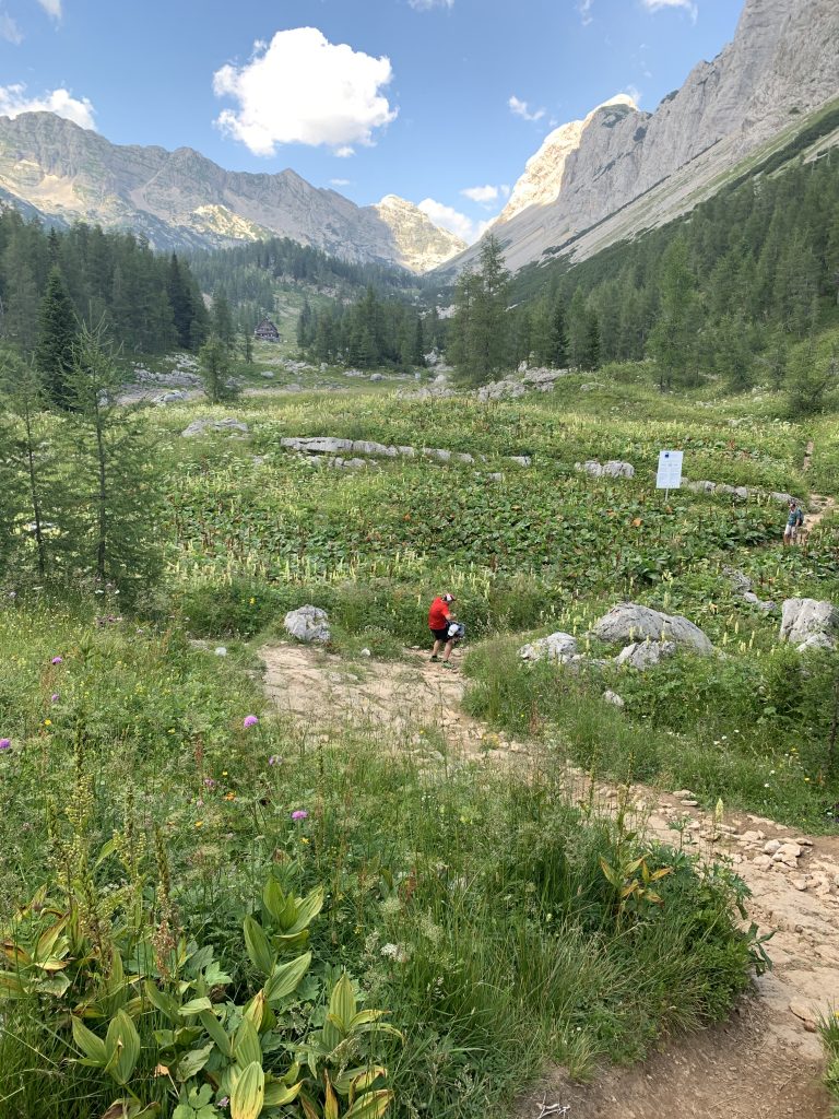
The road up to the Blato Planina begins at Stara Fužina close to Lake Bohinj. From here, for the daily price of €12, you can drive up to 1147m, thus saving lots of energy on the initial ascent. Park in the car park next to Blato, or on the roadside if the car park is full. Follow the signs for the Koča na Planini pri Jezeru – the mountain hut on the plateau by the lake. The walk up to the first mountain hut is steep and rises through evergreen forest without any technical difficulty to emerge in the delightful mountain plain where you can see cattle grazing by the small houses in the shadow of a nearby forest-clad hill:

You can stop here to enjoy some refreshments and rest your feet a little. If you’re lucky, you might hear an alpinist choir singing a-capella harmonies as we did. There is also a lake below the mountain hut.
From here, the Koča pri Triglavskih Jezerih is signposted as a 2hr, 45min walk. We did it slightly faster, and certainly without heavy gear you can make the walk faster than this. But it is a fair estimate with rest-stops. Continue through the forest beyond to reach another remote Alpine village, the Planina Dedno Polje, where you can see dairy cows grazing and buy homemade milk products in summer.
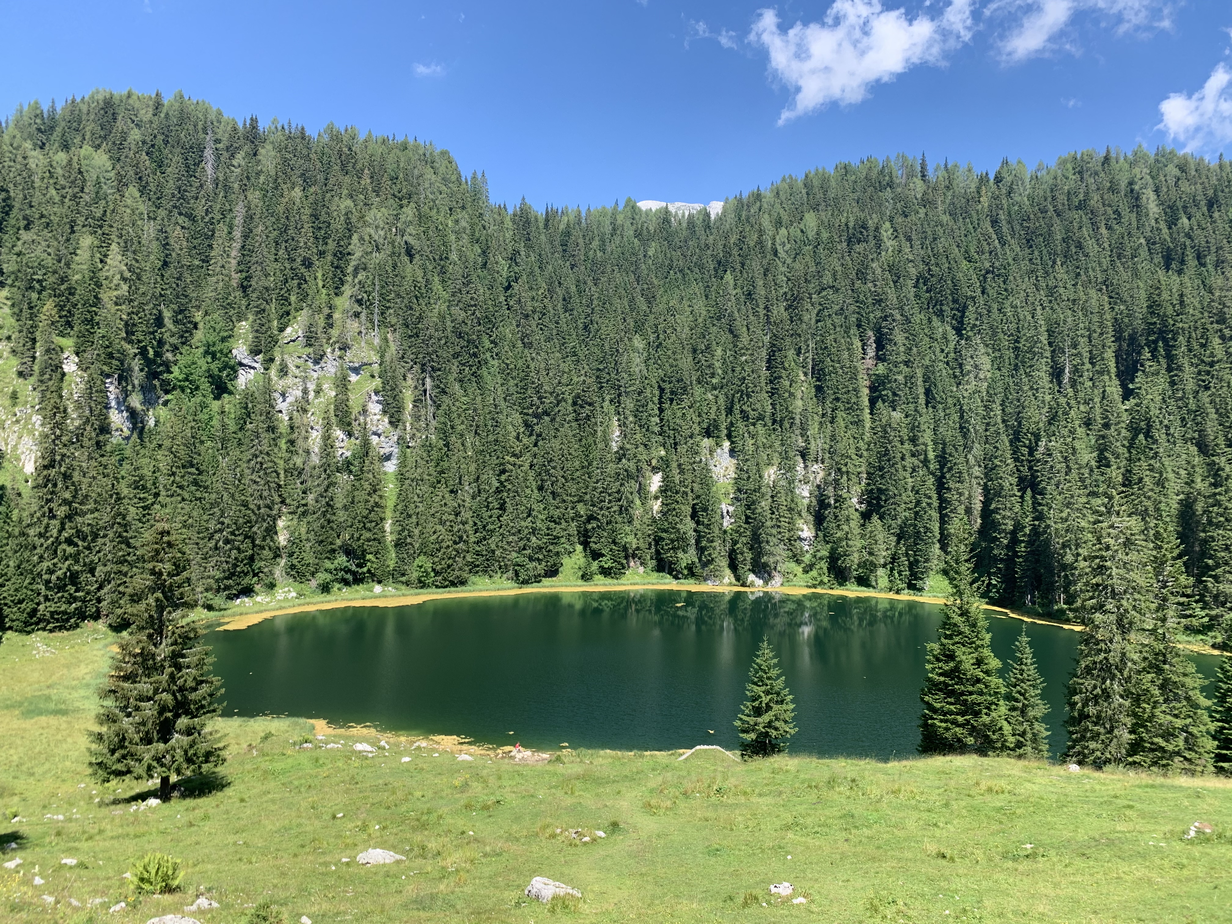
The walk continues winding upwards through a maze of spruce to emerge onto a high plain with a panorama over the lower Bohinj mountains. Dip down again and take the route to the left (there are two routes signposted to the Koča pri Triglavskih jezerih, this is the one we took); you eventually arrive at an open mountain slope with a steep drop to your left. Take care with children here. Once you wind back into the trees, the path leads upwards steadily before emerging into the beautiful Seven Lakes Valley. Take a rest at the Koča, and look for the ammonite fossils in the rock into which the hut is built. From here, you can stay the night and explore the rest of the valley and even climb Slovenia’s highest mountain; or alternatively turn around and retrace your steps. We set off in fine weather but descended in a thunderstorm. For this reason, it is a good idea to start your walk early, as storms often build up during the day in summer.
As for the Planina Blato (‘Mud Plateau’) – I wondered how it got its name until we made the descent in the storm and the path began to form many muddy puddles: for this reason, sturdy footwear is recommended!
A question for the alpinists: I found myself wondering how on earth the Koča pri Triglavskih Jezerih is supplied with food, drinks and gas throughout the summer, with no obvious supply route? I didn’t have the energy to ask the staff, so if anyone can tell me, please do so in the comments section below!
Visit my Instagram page for more photos from this memorable walk, and stay tuned for more Postcards from Slovenia!

Wow, such beautiful scenery and photographs. And the seven lakes, such a romantic and inspiring name!! 😍👌
LikeLike
Thanks Lia – it is a beautiful and inspiring place!
LikeLike
It’s a stonishing landscape. Nice and interesting informaton as well. Thanks for sharing it! ☀️💐
LikeLike
You’re welcome, I’m glad you enjoyed it 😊 ⛰🌲🌼
LikeLike
Truly stunning Ingrid!
LikeLike
Thanks Melody, pleased you liked it 😊
LikeLike
Love my virtual travel!
Thanks so much for posting these beautiful spots!
LikeLike
You’re welcome – it might be the only type of travel available at the moment so pleased you enjoy it 😊
LikeLike
So true! Totally am enjoying them all, thanks!
LikeLike
The Komna route is dangerous for the inexperienced and ill equipped. I think part of its path is being remediated after a fatal incident on it last year. The Blato alternative is preferable for those short of time but should be given similar respect as the route via Komna. Walking up to Vogar is an extension of the latter, with a steep rocky path through the forest presenting a relatively brief challenge. I presume there is a pulley system for transporting supplies to the hut but perhaps they are helicoptered in?
LikeLike
I’m pleased I didn’t recommend the Komna route then! Does it pass above the Savica waterfall? I did wonder about helicopter supplies as I didn’t see any supply lines – next time I will ask!
LikeLike
As far as I can recall the route passes above it, not directly so but close to. Many of the hut walks are best done as part of a multi-day itinerary but at the best of times, it is advisable to book an overnight hut stay in advance. Unless walking the ridge adjacent to the Vogel peak (1922 metres) – Crni Prst-Rodica-etc (which is serviced by the cable car and chair lift) most long(ish) treks involve walking uphill and down, and therefore overnight stops are advised.
LikeLike
You are a real magnet to beautiful scenery Ingrid! No wonder you write such passionate poetry 💕
LikeLike
Yes I’m very lucky to have such sources of inspiration all around me!
LikeLike
And always the perfect answers 😃
LikeLike